
Hurricane season is kind of like the NBA -- it's only the die-hard fans watching until the playoffs (in this case, July and August), when things heat up and meteorological saw blades start cutting the Intertropical Convergence Zone into humid little pieces. Hurricane season may be a late-summer treat on the East Coast, as beloved as saltwater taffy and messing with tourists, but Opening Day was last week and given early forecasts, there's some reason to start paying attention early.
Hurricane Gallery
onClick="window.open('http://espn.go.com/action/surfing/gallery?id=5225398','Popup','width=990,height=720,scrollbars=no,noresize'); return false;">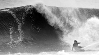 WIDTH="203" HEIGHT="114" BORDER="0" ALT="">
Hurricanes are a lot of hype, but sometimes it all comes together.
onClick="window.open('http://espn.go.com/action/surfing/gallery?id=5264230','Popup','width=990,height=720,scrollbars=no,noresize'); return false;">Gallery »
The hype began nearly a month ago, thanks to measurements of abnormal sea surface temperatures just west of the African coast in the Main Development Region. "SSTs in the MDR, if you're super nerdy," jokes Surfline's East Coast forecaster, Kurt Korte. "This winter we saw the greatest anomaly on record."
Korte forecasts for the Caribbean, Gulf, East Coast and Europe -- all areas that benefit from Atlantic hurricanes. Generally, these areas receive wind swell from storms that track west to east -- the prevailing track in the Northern Hemisphere. Tropical cyclones are a special occasion for the Caribbean and Gulf states, right on up to Nova Scotia, because they can be responsible for rare ground swell -- particularly during the summer and early autumn, when stronger mid-latitude storms are almost nonexistent.
Korte knows all too well what happens on the Right Coast when sunburned, overworked, surf-starved East Coasters let their anticipation meters get higher than the buoy readings, which they already were before late May's preseason tropical swell added to the hurricane season anticipation.
"The main thing," he explains, "is not how many storms we have. That's a common misconception. It all depends on where they form, where they track, and how long they're out there. You could have 20 tropical storms, but if they all form off Cape Hatteras and jet out to sea in one day, what good does that do?"
Typically, the seasonal pattern sees storms that form in the Caribbean and trend toward the Gulf of Mexico, followed by ones that form further east in the Atlantic -- the so-called "Cape Verde" storms. But if that pattern doesn't hold true, you get a year like 2005, which was the most active season on record and one that did squat for the East Coast surfers -- everything went straight into the Gulf.
The Cape Verde storms are the ones that spawn in the previously mentioned Main Development Region. These are the ones that get surfers from Florida to Nova Scotia frothing, located as they are in a swell window that can deliver something for everyone. The froth is compounded by the life cycle of these storms, which can be identified as they form and then tracked across the ocean for a week ahead of any swell. And since one of the most important ingredients in any hurricane is warm water on the ocean's surface to feed the beast, the higher SSTs there are certainly not a bad sign.
The weather community is in agreement that this season has the potential to be very active. El Nino events like the one in effect this past year generally result in high winds at the equator, which create sheer that can limit the potential for storms in the mid-Atlantic. But now that El Nino is phasing out, the National Oceanic and Atmospheric Administration (NOAA) is calling for an "active to extremely active hurricane season" with a 70 percent probability of 14 to 23 named storms and three to seven major hurricanes. The dynamic duo of doctors William Gray and Philip J. Klotzbach at Colorado State University is calling for 15 named storms and four major hurricanes.
We're not talking about meteorological crackpots with ties undone and pit stains, shooting from the hip about the season to come. They've got it down to a, well, a science. Korte regards them as brilliant people, but he doesn't pay much attention to the early season calls.
The swell that got East Coast surfers so excited a few weeks back formed off the southeast coast and had some tropical characteristics. It created several days of moderate waves from Florida to New England. But where it formed is a common area for May systems and has no relevance to the tepid waters in the MDR. And all too often, even storms that reach a favorable swell window end up being duds.
Like so many aspects of surfing, hurricane season gets more unwarranted hype than a Kardashian. The mainstream media love to latch on to any storm that has a name, whipping the general public into a frenzy. Usually, the surfers are way ahead of them in the frenzy department -- "As soon as a storm gets a name, all hell breaks loose," Korte says -- but it's often all for nothing.
"First of all, those long period swells don't always work out. It's kind of a joke," Korte says, "Last year everyone was going ape about Hurricane Bill, but [East Coast] sandbars just can't handle that. We're better suited for 8, 9, or 10 seconds than those 16-second ground swells. New England and Nova Scotia, with all those points, they were loving it."
Surfer and engineer Rick Huegi of Manahawkin, N.J., has been logging wave conditions and water temperature every day for the past 15 years. He has recently begun to record his info into graphs and has one of the most comprehensive amateur databases of East Coast waves.
"You know there is way too much hype around a hurricane swell when your nonsurfing co-workers are telling you the waves are going to be 'rough,'" laughs Huegi. "I have to admit that I get caught up in the hurricane hype too, but 95 percent of the time, I'm extremely disappointed. I'd rather surf a nor'easter at the end of October with powerful northeast lines when the water is still warm and the crowds are less. Swells without hype are always better."
Huegi has a point. The first few "winter" storms often arrive in October or early November, and can be twice as good with half the hype. "Sometimes a hurricane swell can be walled if they stay way out in the ocean," explains Florida's Corey Lopez. "As opposed to winter swells that start stormy and clean up for one epic day of surf."
So, what can we say for sure about the 2010 hurricane season? All the early signs look positive. And the early signs may not mean anything. And even if they do mean something, that's no guarantee that the result will be great, or even good, surf for anyone on the East Coast. But whatever happens, it's a pretty safe bet that the winter storms following hurricane season are going to be worth the wait.
Knowing all this, you would think East Coast surfers might stay on the leash and keep things in perspective when those buggers start spinning.
You would think.